|
HISTORY of WESTERN COVE
Page 3 — 20th CENTURY until the 1970s A BUSY PLACE
Western Cove appeared almost deserted when in 1971 I saw the place for
the first time. I noticed one or two houses and several sheds. Yet
evidence of former activity was obvious everywhere.
A sheep dip built of concrete was situated on the east side of Western Cove Road at the intersection with the Esplanade. Close to the sheep dip were piles of old, broken concrete slabs and rusty iron, apparently the remains of a large demolished shed. About 200 metres west between the Esplanade and the beach stood the ruins of a former house, several walls still up to 2 metres high. Still further west, somewhere near allotment 56 or 58, a narrow wooden jetty protruded into the sea. It was rickety and planks were loose but it could still with care be walked on. Scattered along the beach were rusty artifacts — axles, remains of wheels and spokes, and smaller items. To the east approaching Keel Street was the first of a sequence of ponds, situated between the Esplanade and beach, either dug out or bulldozed decades earlier, to supply water (I guessed) for sheep. Any casual observer in 1971 could have concluded that Western Cove had at times been a busy place. However, details to hand are sketchy. BATES; AYLIFFE; BATES; HAMMAT
For how long
Ephraim S. Bates remained the owner of the land shown on the 1882 map
(see previous page) is presently unknown.
In 1904 Gerald Gleeson Ayliffe of Adelaide purchased land at Western Cove but its location in relation to E.S Bates' property is uncertain. Peter Hawkins says: "I have a copy (from the Lands Titles Office) of the Agreement for Sale and Purchase of Section T in the Hundred pf Haines, being 100 acres, from the Commissioner of Crown Lands to Gerald Gleeson Ayliffe dated 23rd November 1904, for the sum of fifty pounds." The booklet Kangaroo Island in 1905 (by E.H. Hallack) mentions G.G. Ayliffe as a "new settler" who owned land at Western Cove:
A 1911 newspaper report titled "Progress and Problems" said in part:
Gerald Gleeson Ayliffe (1873-1946) fought
in the Boer War, served as District Clerk
with the Kingscote Council and as a J.P., was captain of
the Kingscote Rifle Club, and a vice president of the Kingscote Racing
Club. These
and other
activities got him mentioned frequently in Adelaide and KI newspapers
for over 40 years.
In November 1921 G.G. Ayliffe sold to William Walter Bates who became the owner of 100 acres for the sum of 50 pounds. (Agreement for Sale and Purchase, Volume 500, Folio 98, No. 5148). Whether this "Bates" was related to E.S. Bates needs checking as KI has several unrelated familes named Bates. The "100 acres" appears to have been more exactly 96 1/2 acres which is the acreage specified when a Lewis Bruce Bates inherited the land in 1950. (Land Grant, Vol. 1490, Folio 111) Lewis Bruce Bates is not the Bruce Bates pictured in the photo, previous page. The next owners in 1955 were Frederick Rolland Hammat and Henriette Dorothea Hammat both of Kingscote. "George" of Kingscote (who installed my antenna in 2011) said he regularly came to Western Cove as a kid in the 1960s and knew of a teacher named "Hammat" who had lived there and whose house burned down. The Transfer, however, lists Frederick as a grazier and for Dorothea home duties, and both of Kingscote. In 1961 the land was transferred to Nepean Development Limited. RAILWAY 1907; EVANGELIST 1914; OYSTERS 1930s; SHARKS 1933;
BOAT CAPSIZE 1979; CONSERVATION PARK 1974
1907 saw proposals for constructing a railway
line on KI extending to Western Cove to
encourage more farmers to settle on the Island and lead to greater
prosperity. But it never went ahead.
1914: Did the world's greatest evangelist visit Western Cove in 1914? Click here to consider the evidence. In the 1930s oysters were grown east of Western Cove. The effort lasted about ten years and the concrete structures associated with oyster farming are still visible in the sea. Currently three oyster farms operate about six kilometres east near the Red Banks. Apparently the area between the Esplanade and Oceanview Drive was at some stage a potato farm but no details are presently available. An article in The Advertiser in 1933, titled Insatiable Carnivorous Sharks Abound, includes an incident at Western Cove:
A website that lists Kangaroo Island Shipwrecks says:
This seems to be the same incident mentioned by Cordes (1986):
Nepean Bay
Conservation Park to the east of Western Cove was dedicated
in 1974 for the protection of flora and fauna, and is the only reserved
area of coastal sandplain on KI. A description from Wikipedia reads:
CHIRGWIN
Besides
Thompson, Willson, Bates, Chenoweth, Ayliffe and Hammat another name
associated with
Western Cove history is "Chirgwin".
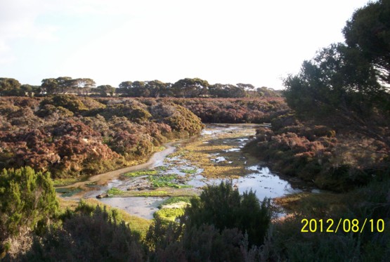
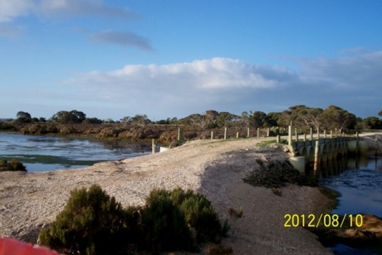
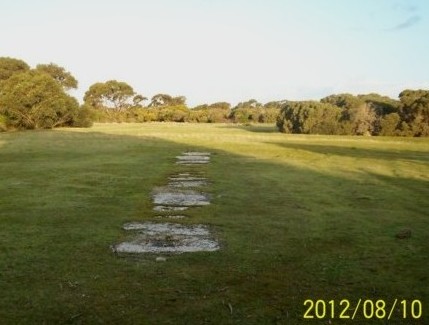
Tim Chirgwin's property is bounded by Hog Bay Road, Western Cove township, and the coastal samphire west of the township. Mr Chirgwin's father and grandfather were both born on the Island. [There is a genealogy of the Chirgwins on the family history shelf at the Kingscote Museum.] The photos below were taken on Mr Chirgwin's land and show: 1
Seawater through
coastal samphire;
2 A bridge on Mr Chirgwin's property; 3 A long-disused, cricket pitch where KI residents used to play cricket.
WESTERN
COVE OR NEPEAN BAY?
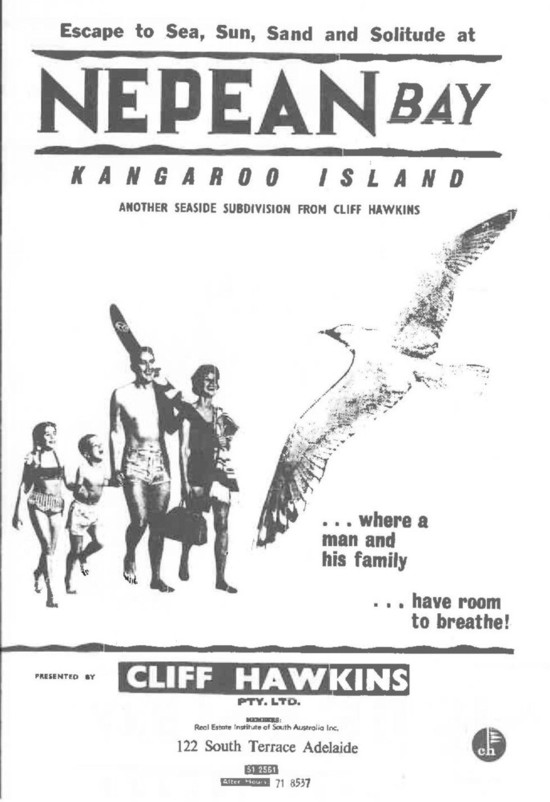
The township that became Western Cove was laid out by Nepean
Developments Ltd. in 1961 and approved for subdivision in 1963.
In 1967 Cliff Hawkins Pty. Ltd. was appointed sole selling agent. The first allotment sold was No. 243 on Sea Vista Road (November 30th, 1967) and by 1973 all of the 246 allotments within the estate were sold. Front page of Cliff
Hawkins Sale Brochure (1967)
For decades
people including realestate agents referred to the area as "Nepean
Bay". After the turn of the century "Western Cove" became more usual
and is the name used in this history.
Peter Hawkins explained by e-mail:
In March 2017 the KI Council assigned street numbers to properties
which, however, can still be identified by their allotment numbers. The
letter notifying me of my street number referred to the township as
"Nepean Bay Township" and "Nepean Bay". The Sealink map for tourists
has since at least 2013 (which is my oldest copy) used both names — "Nepean Bay" and, in brackets, "Western Cove".
|