HISTORY of WESTERN COVE
Page 1 — 1802 to the 1880s
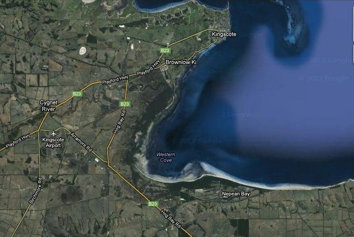
Google Satellite (Copyright 2012)
EXPLORATION –
MATTHEW FLINDERS
English navigator Matthew Flinders (1744-1814) discovered Nepean Bay and Western Cove in 1802.
Flinders commanded a scientific expedition on the 334-ton sloop Investigator from 1801 to 1803 and mapped Australia's southern coast including the north coast of Kangaroo Island.
Flinders reached the north coast of Kangaroo Island on Sunday, March 21, 1802, sailed east along the coast, and named Marsden Point and Nepean Bay.
In his book Voyage to Terra Australis (1814) Flinders writes:
|
At ten o'clock we
were close under the land; and finding the water tolerably smooth, had
shortened sail with the intention of anchoring near a small, sandy
beach; but the situation proving to be too much exposed, we steered
eastward along the shore under two close-reefed topsails and fore-sail,
the wind blowing strong in squalls from the south-west. The furthest
land seen ahead at noon was a projecting point, lower than the other
cliffs; it bore E. 7° S., four leagues, and and lies in 35° 33'
south
and 137° 41' east. It was named Point Marsden, in
compliment to the
second secretary of the Admiralty; and beyond it the coast was found
to
trend southward into a large bay containing three coves, any one of
which promised good shelter from the gale. This was called NEPEAN BAY,
in compliment to the first secretary (now Sir Evan Nepean, Bart.), and
we hauled up for it; but the strength of the wind was such that a
headland forming the east side of the bay was fetched with difficulty.
At six in the evening we came to anchor in 9 fathoms, sandy bottom,
within a mile of the shore...
|
The three coves Flinders named "Bay of Shoals", "Seal Bay" (now "Western Cove"), and Lagoon Bay (now "Eastern Cove").
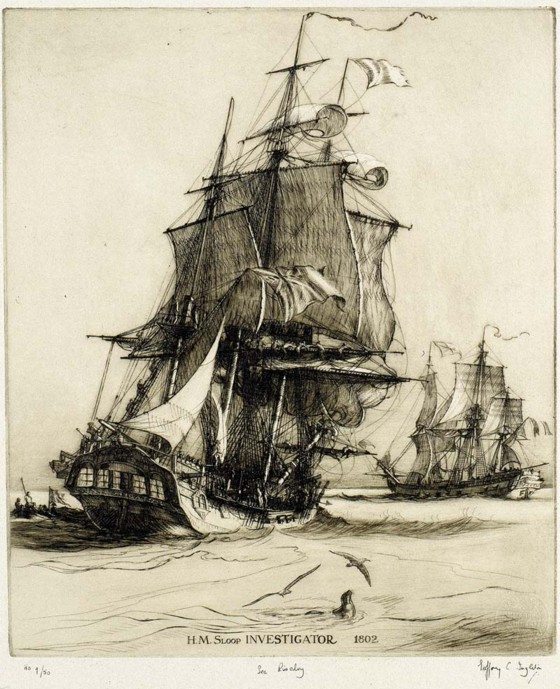
H.M. Sloop Investigator
A copy of a photograph of an etching from the State Library of New South Wales
A copy of a photograph of an etching from the State Library of New South Wales
NICOLAS BAUDIN
The second explorer to reach Nepean Bay was Captain Baudin (1754-1803). His ship Le Geographe arrived at the south-west tip of Western Australia in May 1801. He sailed north to Timor, then to Sydney and Tasmania and surveyed Australia's southern coast up to Encounter Bay east of Kangaroo Island.
Le Geographe and Flinders' ship Investigator met on April 8, 1802 in Encounter Bay near the mainland and the captains held a conference on Le Geographe. Baudin then sailed back to Sydney.
In November, 1802, Baudin sailed Le Geographe south again, accompanied by Le Casuarina commanded by Louis de Freycinet and repeated some of the work done by Flinders.
During Baudin's second survey of the southern coast the French ships circumnavigated Kangaroo Island from January 2 to 6, 1803.
On board Le Geographe, sharing Baudin's cabin, was 16-year-old Mary Beckwith, an escaped convict, who became the first European female to walk on Kangaroo Island. From January 6th to February 1st the ship anchored in eastern Nepean Bay i.e. Eastern Cove where Mary went ashore at Baudin Beach. She was probably also the first European female to set eyes on Western Cove since Le Geographe sailed past at least twice.
Francois Peron (naturalist on the Baudin expedition) and de Freycinet published accounts of the French expedition in 1807 and 1812 in which all the main features had French names. Australia's southern coast, for example, was "Terre Napoleon" and Nepean Bay was "Bougainville Bay". Freycinet's second edition (1824) had the French names removed except for places the French had been first to survey.
FIRST
SETTLERS on KI
From 1804 to 1836 the Kingscote area was home to an assortment of marooned whalers, runaway sailors, escaped convicts, aboriginal women, and other unofficial settlers numbering up to about 30.
Some of these would, in searches for fresh water or other resources, have walked to Western Cove or rowed or sailed there across Nepean Bay.
In 1814 salt gathering started at White lagoon about 20km south of Western Cove; and in the 1820s self-proclaimed "governor" Robert Wallen lived and farmed at Cynet River about 6km north-west of Western Cove.
VISITORS
During this early period explorers continued to visit Kangaroo Island of whom several are discussed in History of the British Colonies Volume IV (1835). Although Western Cove is not mentioned by name the visitors almost certainly walked through or past Western Cove:
In 1819 Captain Sutherland stayed on Kangaroo Island from January to August. Twelve years later in 1831 he reported to a committee in London investigating whether South Australia was suitable for establishing a colony:
| "From a point five
miles S. of Point Marsden a sand spit runs out at least six miles in a
south-easterly direction, which is not mentioned in any of the English
charts. Captain Sutherland says 'that twenty ships could moor within 100 yards of the shore, and the same number anchor in safety further off, the water being always smooth, sheltered by the land from the N.W. , and from the southward by Kangaroo Head, and from the N.E. by Sutherland's shoal, extending from the point below Point Marsden about six miles..." (p. 489) |
This seems to describe Eastern Cove near American River since Captain Sutherland mentions, "Cape Jervis, which I should judge to be about fourteen or fifteen miles from the first anchorage..."
Captain Sutherland and his crew did plenty of walking during their 7-month stay:
| "I once crossed the
island, a distance of about 60 miles in two days. Once passed the belt
of wood which surrounds the island, we walked straight on end over the
plains, found plenty of water in ponds, saw abundance of kangaroos and
emus... (p. 490) "I had fifteen men under my command, and though they were a class of people who take no care of themselves, not one of them was ill during our stay, nor did my own health suffer at all, though I was exposed to all weathers both day and night." (p. 491) |
Captain Sutherland apparently visited the south side of Kangaroo Island since he says there are no harbours there. Also the Kingscote area since he mentions Europeans living on the island who "are complete savages, living in bark huts" , dressed "in kangaroo skins without linen", and "smell like foxes". (p. 492)
Another visitor was Richard Wootten, Steward of the brig Guardian who, "landed about 12 miles W. of Point Marsden, with some shipmates and dogs, to shoot kangaroos, walking towards Nepean Bay, where his ship was to anchor... He remained on the island three weeks..." (p. 493)
OFFICIAL COLONISATION
Official colonisation of South Australia began July 27, 1836, at Kingscote when the 190-ton ship Duke of York anchored in Nepean Bay and the people disembarked.
The second vessel to arrive was the 239-ton Cygnet which in September, 1836, anchored at the mouth of the Cygnet River about 3 kilometres from Western Cove beach.
The 316-ton Africaine arrived on 2nd November 1836 and anchored in Nepean Bay for five days.
Journal entries of the Africaine describe the area around Kingscote as "interminable" scrub, like a "labyrinth" (and Western Cove at the time would have been similar) :
"...during a walk which
I
took
with my husband we entered the scrub, as it is called, and incautiously
proceeded till we were so completely bewildered that we began to be
uneasy lest we should not find our way out of the labyrinth, which
seemed on all sides to be interminable, for nothing could be seen but
the sky above us and the bushes around us. Nor could we tell which way
to retrace our steps, as no path which we had passed through was
discernible. At length, however, after advancing, as far as we could
judge, about half a mile, we fortunately caught through a small opening
in the brushwood a glimpse of the sea, and immediately made towards it,
forcing our way through the bushes..."
|
The "Africaine Tragedy" occurred at that time. Six men left the ship near Cape Borda, intending to proceed on foot and rejoin the other pasengers at Kingscote. Even today with much of the land cleared such a walk would be difficult. In 1836 there were no roads, and barriers of dense scrub forced them to head southwards. Two of the group died during the ten-day walk. A map in Cordes (1986) and on the Kangaroo Island Pioneers Association website shows the route the men took. They headed SE to Vivonne Bay, NE to Pelican Lagoon, then NW along the coast of Western Cove to Kingscote.
(https://sites.google.com/site/kipaview/history/journal-of-robert-fisher)
Kingscote's population in 1836-1838 reached 300, living in tents and huts of wood or stone along the shore. Due to poor soil and lack of water most of them relocated in 1838 to Adelaide. Several dozen stayed at Kingscote where from 1840 to 1841 they quarried basalt rock which was shipped to Adelaide and used for road construction.
POLICE ACTION —
1844
There was a police pursuit on KI in August 1844, led by Inspector of Police Mr. Tolmer.
While on KI the police collected information about the Island which was published in Adelaide newspapers. The report mentions locations where people lived and gives many of their names and occupations and says that the residents of the Island numbered 80 — "33 white men, 13 white women, 10 black women, 21 white and 3 half-caste children."
Western Cove is not directly mentioned. But the police would have come close to Western Cove since their search and pursuit took them to Point Morrison to the east, Kingscote to the north, and Duck Lagoon to the west.
THE FIRST FARM at WESTERN
COVE — 1860s
Adelaide newspapers in the 19th century occasionally mentioned Western Cove from the 1860s onwards when listing land leases or when describing the Island.
A Reverend C.W. Morse visited KI in 1869. A report of his entire trip was published in the Adelaide Register. Describing his departure from American River the Reverend writes:
| "I started for Kingscote, 35 miles. The path — track one could scarcely call it — lies for about seven miles through a dense scrub, which is not at all pleasant to ride through after rain. We came out upon Nepean Bay, on the other side of Point Morrison, and came upon a hut on the shore, where I baptized an infant. Proceeding on round the Bay for nine miles, we came to a farm, where I christened another child. This is called the Bight of the Bay, and here we struck inland for the Cygnet, or Three-Well River." |
Nine miles from Point Morrison would be Western Cove, also called the "Bight of the Bay". Evidently a farm existed at Western Cove already by 1869 and therefore also a house or hut. And since the Reverend christened an infant the inhabitants would include at least one man and one woman.
By 1884 this first family at Western Cove had apparently departed. A group of travellers from Adelaide visited KI in that year (1884) and discovered a ruined hut and freshwater well at Western Cove. A long report in the South Australian Chronicle includes this comment: "We gradually worked our way round to Western Cove at the head of the bight, where we found the ruins of a hut and a well of fresh water. Here we camped…" (26 April, 1884)
During my first wanderings around Western Cove in 1977 I came across a small, four-walled, square, concrete structure near the beach in the Conservation Reserve. From memory it was about 50cm high and 50cm wide, and the walls about 10cm thick. Sheoaks, bushes and debris made a close inspection difficult. I left it untouched but have occasionally remembered, and wondered who built it and what for.
In 2015 I found the above newspaper reports on the "Trove" website and, on reading "we found the ruins of a hut and a well", I wondered whether the concrete structure that I saw in 1977 originally formed part of the hut or well.
NEWS REPORTS
The earliest news report that I've found about any incident at Western Cove is from The Adelaide Observer of 1873:
|
"■ Ship Ashore.—From
American
River, one of our Kangaroo
Island correspondents reports in a letter dated March 4:—"The large
ship, City of Shanghai, was discovered on shore in Western Cove, Nepean
Bay, on Monday, March 3, in a position not far north of the two wells
on the east-side. I started on Tuesday morning for the scene, but found
that she was gone. I learnt that a boat from Kingscote went to her aid
on the Monday, and the captain agreed to hire the boat to take him to
Cape
Jervis on Tuesday morning to fetch a steamer. An extraordinary tide
enabled him to get off, and the vessel is presumed to have pursued her
voyage, as she was seen on Tuesday making all sail via Point Marsden.
The captain states that the mistake occurred by his taking Point
Morrison for Point Marsden." It will be remembered that the ship City
of Shanghai left Port Adelaide on March 2."
(15 March, 1873, p. 9)
|
Another ship incident occurred in 1885 in Nepean Bay, about 12-13 km north-east of Western Cove beach. The "Fanny M" carrying a cargo of coal ran aground on a sand spit. The ship and coal caught fire and burned completely. All eleven crew members survived.